By
Joe Edwards is a Live News Reporter based in Newsweek’s London Bureau. He covers topics related to weather, climate, and extreme weather events. Joe joined Newsweek in April 2024 after graduating from City, University of London with an MA in International Journalism. Prior to this, he studied History and English Literature at the University of Kent. Languages: English. You can get in touch with Joe by emailing joe.edwards@newsweek.com
Joe Edwards
Live News Reporter
🎙️ Voice is AI-generated. Inconsistencies may occur.
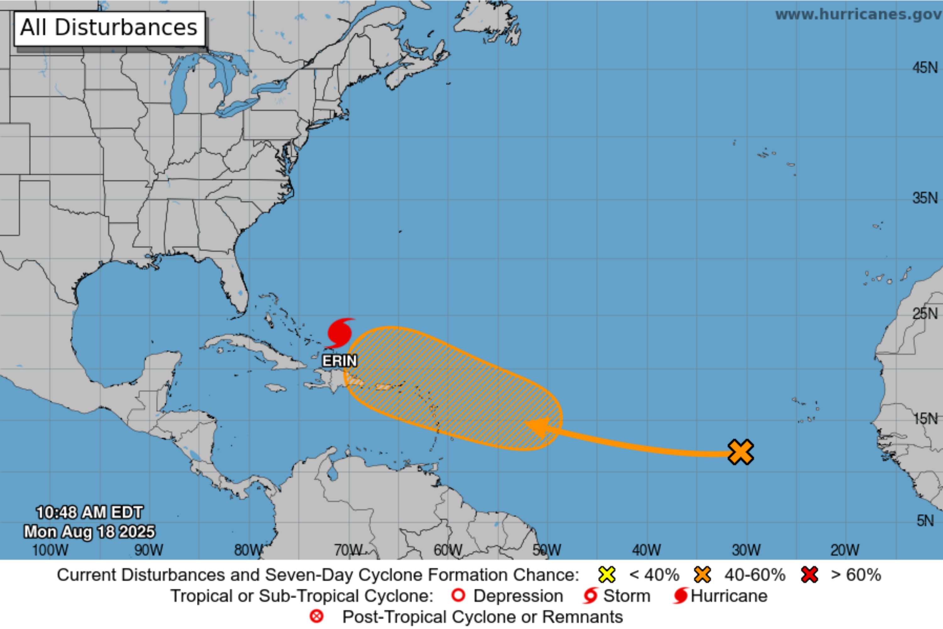
An Atlantic disturbance’s chances of cyclone formation have jumped from 20 percent to 50 percent between Sunday and Monday, according to forecasters at the National Hurricane Center (NHC).
Why It Matters
Meteorologists are monitoring the disturbance after Erin became the first hurricane of the 2025 Atlantic season on Friday.
According to experts at AccuWeather, Erin underwent one of the fastest intensifications ever recorded, strengthening from a tropical storm to a Category 5 hurricane in just 27 hours and 20 minutes.

National Hurricane Center
What To Know
“A tropical wave located over the eastern tropical Atlantic is producing disorganized showers and thunderstorms,” the NHC said in an update on Monday. “Environmental conditions appear conducive for gradual development of this system, and a tropical depression could form during the latter part of the week.”
The system was expected to move westward to northwestward at about 20 mph, approaching the Leeward Islands near the end of the week, the NHC said.
The agency estimated a 50 percent chance of cyclone development through the next seven days—a notable increase from the 20 percent chance over a similar time frame reported on Sunday.
Meanwhile, the NHC said that Hurricane Erin was about 120 miles north of Grand Turk Island. Erin returned to Category 4 strength on Sunday after being briefly downgraded.
The agency reported it was moving west-northwest near 10 mph, with a northwestern turn expected later on Monday, and a turn north on Tuesday.
The NHC said maximum sustained winds had increased to near 140 mph, with further strengthening anticipated on Monday. The system would remain “a dangerous major hurricane” through the middle of the week, it added.
Tropical storm warnings were in effect for the Turks and Caicos Islands and the southeast Bahamas, according to the NHC.
What People Are Saying
NHC hurricane specialist Larry Kelly told Newsweek on Monday: “As of August 18 at 2 p.m. EDT, there is a 10 percent chance of development in 48 hours and 60 percent in seven days.
“Those in the Leeward Islands and Lesser Antilles should monitor the progress of this system over the coming days as it approaches the islands later this week with updates at hurricanes.gov.
“Although it is still too early to know what and if impacts, this is a good reminder as we approach the climatological peak of the hurricane season, this is an opportune time to ensure your preparedness plans are in place.”
The National Hurricane Center, on X on Sunday night: “In addition to #Erin, the tropical wave in the eastern Atlantic now has a medium chance of tropical cyclone formation within the next 7 days. The system should approach the NE Caribbean or SW Atlantic by the end of this week.”
Meteorologist Spinks Megginson, on X on Monday: “Hurricane Erin has strengthened this morning. Maximum winds up to 140 mph in the 11AM EDT advisory. Erin will move north over the next day or so before turning northeast in between North Carolina and Bermuda. Core of Erin will miss land areas in the days ahead, thankfully.”
What Happens Next
The NHC issues frequent updates on its website and social media channels. The agency said Erin was expected to move between the U.S. East Coast and Bermuda this week.
Update 8/19/25, 12:49 p.m. ET: This article was updated with comment from Larry Kelly.
Is This Article Trustworthy?
![]()
Newsweek is committed to journalism that is factual and fair
We value your input and encourage you to rate this article.
Newsweek is committed to journalism that is factual and fair
We value your input and encourage you to rate this article.
Top stories
About the writer
Joe Edwards is a Live News Reporter based in Newsweek’s London Bureau. He covers topics related to weather, climate, and extreme weather events. Joe joined Newsweek in April 2024 after graduating from City, University of London with an MA in International Journalism. Prior to this, he studied History and English Literature at the University of Kent. Languages: English. You can get in touch with Joe by emailing joe.edwards@newsweek.com
Joe Edwards
Joe Edwards is a Live News Reporter based in Newsweek’s London Bureau. He covers topics related to weather, climate, and …
Read more